Around Stromness

This is a nice pictorial map of Stromness, showing the layout of the town. Well Park is marked at bottom left, next to the George Mackay Brown Garden. Stromness Museum is shown at left middle and Graham Place (where H works at the Red Cross shop) can be seen in the centre, indicating our long commutes to work. The map also shows the locations of the blue plaques, dotted through the town, showing points of historical interest.
Super Moon over the Flow
Got this shot of the moon over Houghton Head. The wisps of cloud made it appear to be wearing a bandit mask.

Wintry Hoy Ahoy
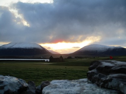
We don’t get too much snow in Orkney, so it’s always nice to see the neighbouring island of Hoy with a touch on the hills. The roofless building in the centre was Stromness’ first lifeboat station. Established in 1867, 2017 was the 150th anniversary and was marked by the unveiling of a plaque at the old station and a flotilla of the local lifeboats into the harbour.

Up Hellihole
Just outside Gray’s Noust is the bottom of Hellihole Road, a name which seems to amuse the visitors and is much photographed. It’s one of the steeper roads in Stromness and can be tricky in winter. The building is the former Stromness Library and is now an Arts Studio.

Climbing the hill, the road passes Stromness’ “Leading Lights” (not me and H, as I’m sure you thought). The two lights, when aligned, guide shipping into the harbour below.

The name Hellihole is derived from “Haley Hole”, a mineral well nearby, which was believed to have health giving properties. At one time it was visited by pilgrims who considered it a “miracle well”.
Around the corner, on Back Road, is this nice little cottage, The beehive structure on the corner was a type of kiln used for drying grain.

Continuing along Back Road, we can detour up to the “Citadel”, this was the site of an Anti Aircraft battery in WWII and gives great views over Hoy Sound. In the foreground is the site of the Ness Battery, first established in 1914 and updated in 1938. It guards the western entrance to Scapa Flow.

The Citadel also gives a good view to the east, past Hoy High lighthouse (on Graemsay) across the Flow to Cava and Flotta.

From here it’s just an easy 10 minute stroll downhill back home. A nice wee walk.
The Old Warehouse Buildings

This is another of Stromness’ blue plaques, recording that the “Old Warehouse Buildings” were built in the 1760s for the storage of rice brought from the American colonies during the Seven Years War. This building now houses the new library, the Council offices and the Police station but has no signage indicating this. Stromness operates on a need to know only basis, also known as “aabody kens”.
Groatie Buckies

These little shells are “groatie buckies”, or spotted cowries. They are much sought after by Orcadians for good luck. It is common to see entire families bent double, scouring the beaches in search of them.
Stromness Sailing Club
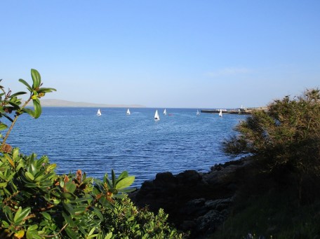
Thursday evenings see Stromness Sailing Club out on the water for their weekly get together. Here they are in Stromness Harbour enjoying a beautiful evening.
Mapping the Town
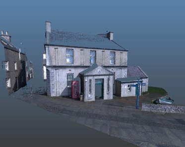
The main streets of Stromness are to be scanned using a laser 3D scanning system. A team from Robert Gordon University (RGU) carry out laser scanning of the town’s historic and architecturally unique Victoria Street, capturing key points such as well-known building facades and the topography and layout. This is their scanned image of Stromness Museum. (Article from The Orcadian).